Diagram of latitude and longitude game quiz online
 Throughout the millennia, mankind has travelled and explored much of the world to found colonies, gain access to valuable resources, meet the peoples in faraway lands, and exchange ideas and technologies. Exploring the world would be much harder without maps. Over the years, people have developed methods to help in properly identifying the exact location of certain lands, landmarks, and routes. If you notice the criss-crossing lines of a map, you can see one such method at work – the latitude and longitude coordinate system. Don’t feel silly for confusing these two terms. Think of the longitude as a vertical line (meridian) extending from the equator to both poles. On the other hand, a latitude can be viewed as a horizontal line (parallel) encircling the world, starting from the prime meridian in the United Kingdom. By organizing the world into a grid, the exact coordinates of a particular place can be defined through its latitude and longitude. In effect, longitudes describe the position of a place from east to west, while latitudes describe north to south. You can use this
diagram of latitude and longitude
as a valuable resource for learning how to read the coordinates of important locations accurately and more efficiently.
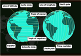
Throughout the millennia, mankind has travelled and explored much of the world to found colonies, gain access to valuable resources, meet the peoples in faraway lands, and exchange ideas and technologies. Exploring the world would be much harder without maps. Over the years, people have developed methods to help in properly identifying the exact location of certain lands, landmarks, and routes. If you notice the criss-crossing lines of a map, you can see one such method at work – the latitude and longitude coordinate system. Don’t feel silly for confusing these two terms. Think of the longitude as a vertical line (meridian) extending from the equator to both poles. On the other hand, a latitude can be viewed as a horizontal line (parallel) encircling the world, starting from the prime meridian in the United Kingdom. By organizing the world into a grid, the exact coordinates of a particular place can be defined through its latitude and longitude. In effect, longitudes describe the position of a place from east to west, while latitudes describe north to south. You can use this
diagram of latitude and longitude
as a valuable resource for learning how to read the coordinates of important locations accurately and more efficiently.